
Volume
Map 3D terrain & calculate volume
Generate 3D terrain maps, calculate true surface area, volume, and contour lines.
Choose your Moasure

Try it with our 60-day money-back guarantee
How it works
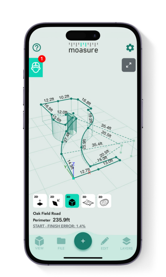
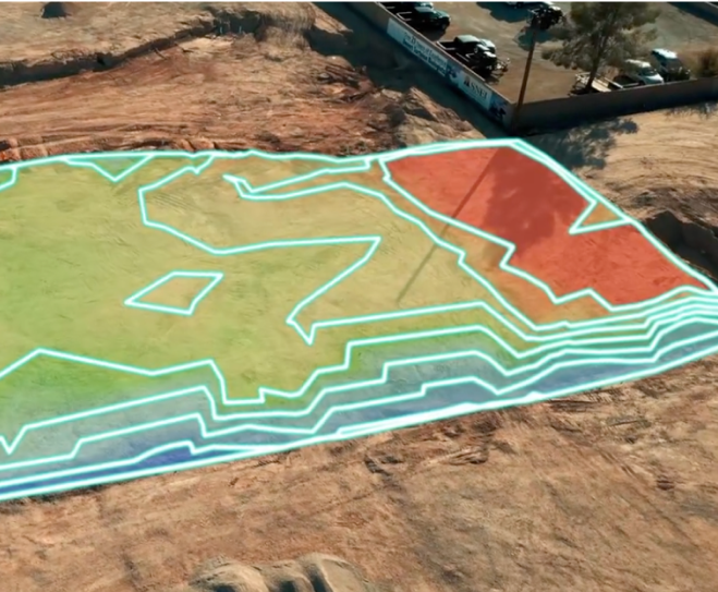
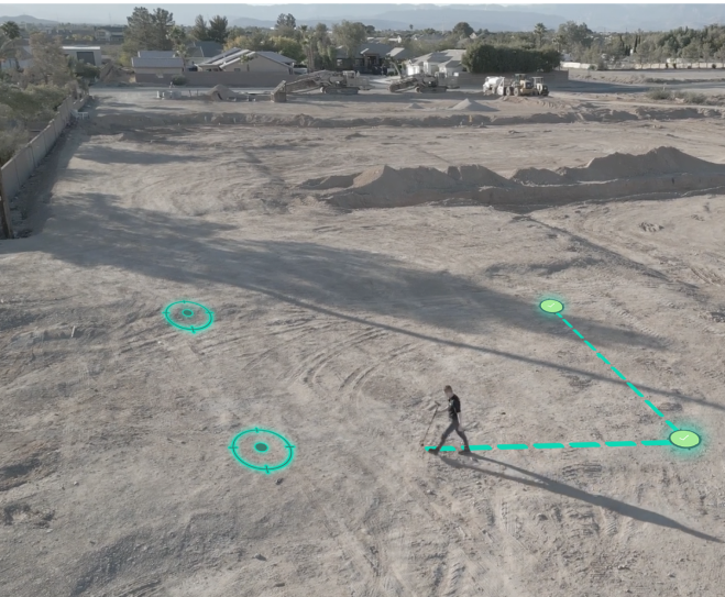
Rapidly generate an accurate 3D terrain map of any space
Plus, make earthwork projects more efficient and profitable using the in-app Cut & Fill and Add Depth tools.
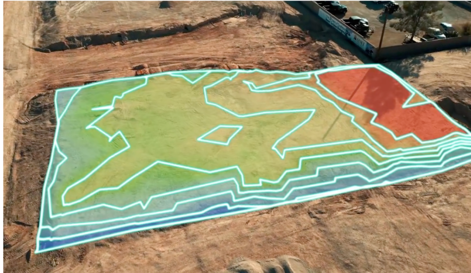
Measure 3D terrain & topography with various views
By simply moving Moasure around a job site, stockpile or excavation area, Moasure instantly captures the volume and surface area. See your 3D data in multiple ways, like surface mesh and contour views, to further enhance your measurements.

1
1
2
2
True surface area calculated instantly
Moasure's ability to capture additional points using the Points path type allows for quick measurement of undulating sites, determining the true surface area effortlessly.
Measure stockpiles & calculate remaining material
Eliminate guesswork and scrap the complicated tools when it comes to estimating stockpile volumes. Use Moasure to calculate material volumes, prevent shortages or overages, and streamline your supply chain.
3
3
4
4
Utilize various in-app volume tools
Moasure makes levelling or adding depth to an area easy. Using the built-in tools, calculate the volume required to cut or fill for site leveling, or even calculate net zero volume. Add depth to any measurement using the simple slider.
Export your volume measurement data in 3D
When your measurement is complete, export your volume data directly into your preferred CAD software or as a PDF, CSV, or image file. Moasure integrates seamlessly into your existing workflow, making it easier than ever to share and present accurate 3D data.
5
5


Save on material waste, maximize profits, & eliminate errors
Try Moasure today and experience the savings firsthand.
Choose your Moasure

Try it with our 60-day money-back guarantee
The easiest way to measure volume across any terrain
Watch this short video to see how easy it is to measure in 3D using Moasure.
Choose your Moasure
Try it with our 60-day money-back guarantee
TOOLS
Utilize a range of volume tools
Utilize the Moasure app's powerful suite of tools and features to inspect and enhance your measurements.
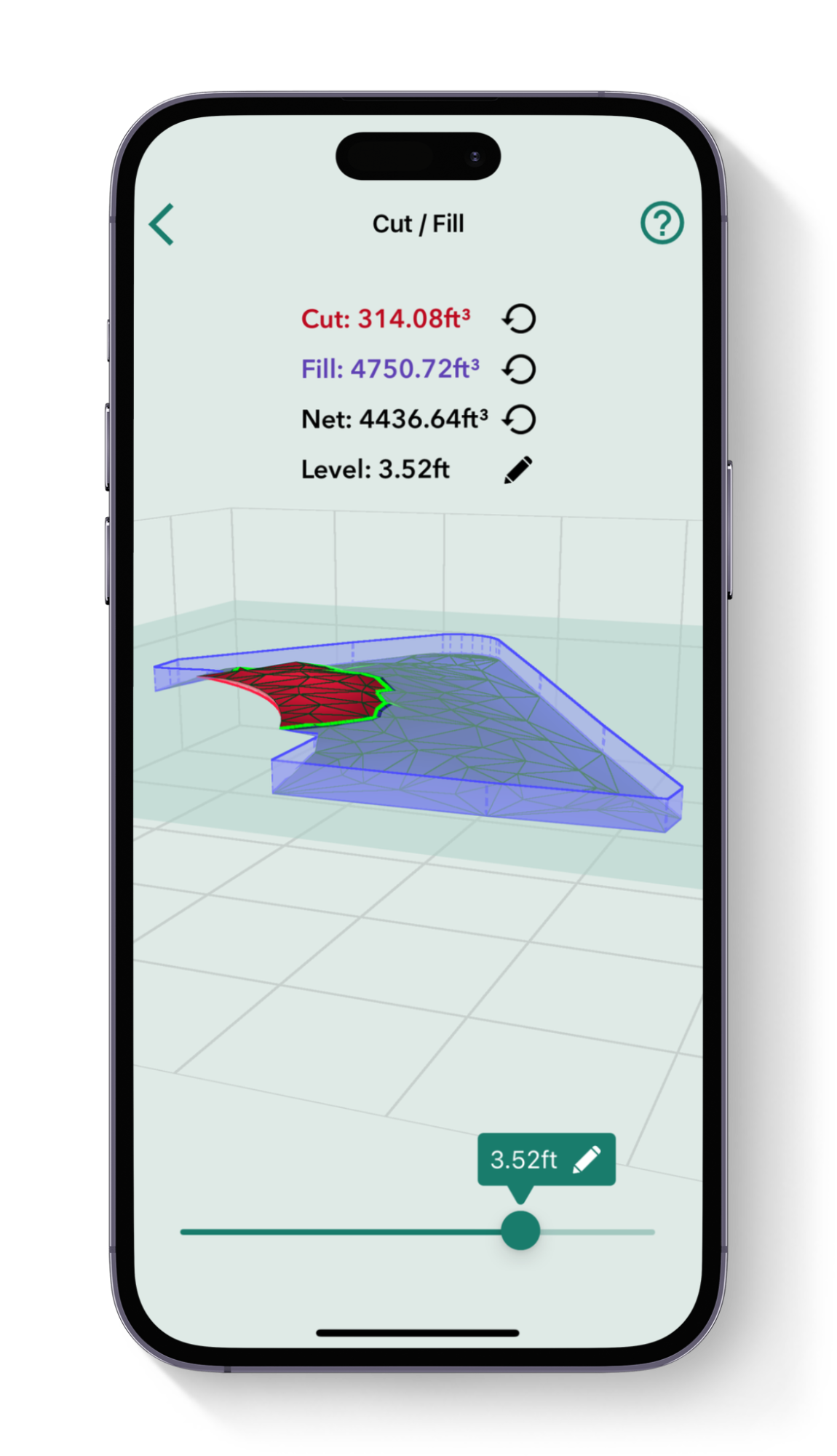
Cut & Fill
Calculate the volume of material needed to either excavate (cut) or add (fill) to bring a site to the desired level. Set your preferred level and instantly see the volume required for adjustments. The “zero net volume” feature shows the exact level needed to avoid any material movement, making it useful for leveling sites in landscaping and construction.
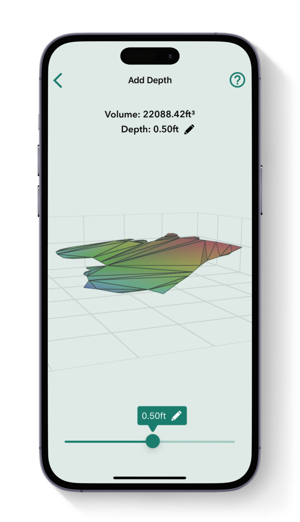
Add depth
Designed for estimating material volumes based on specific depths, this tool calculates how much material (like mulch, soil, or aggregate) is needed to cover a given area at a set depth. It’s effective for both flat and sloped sites, helping you avoid overestimating material costs and ensuring precise coverage.
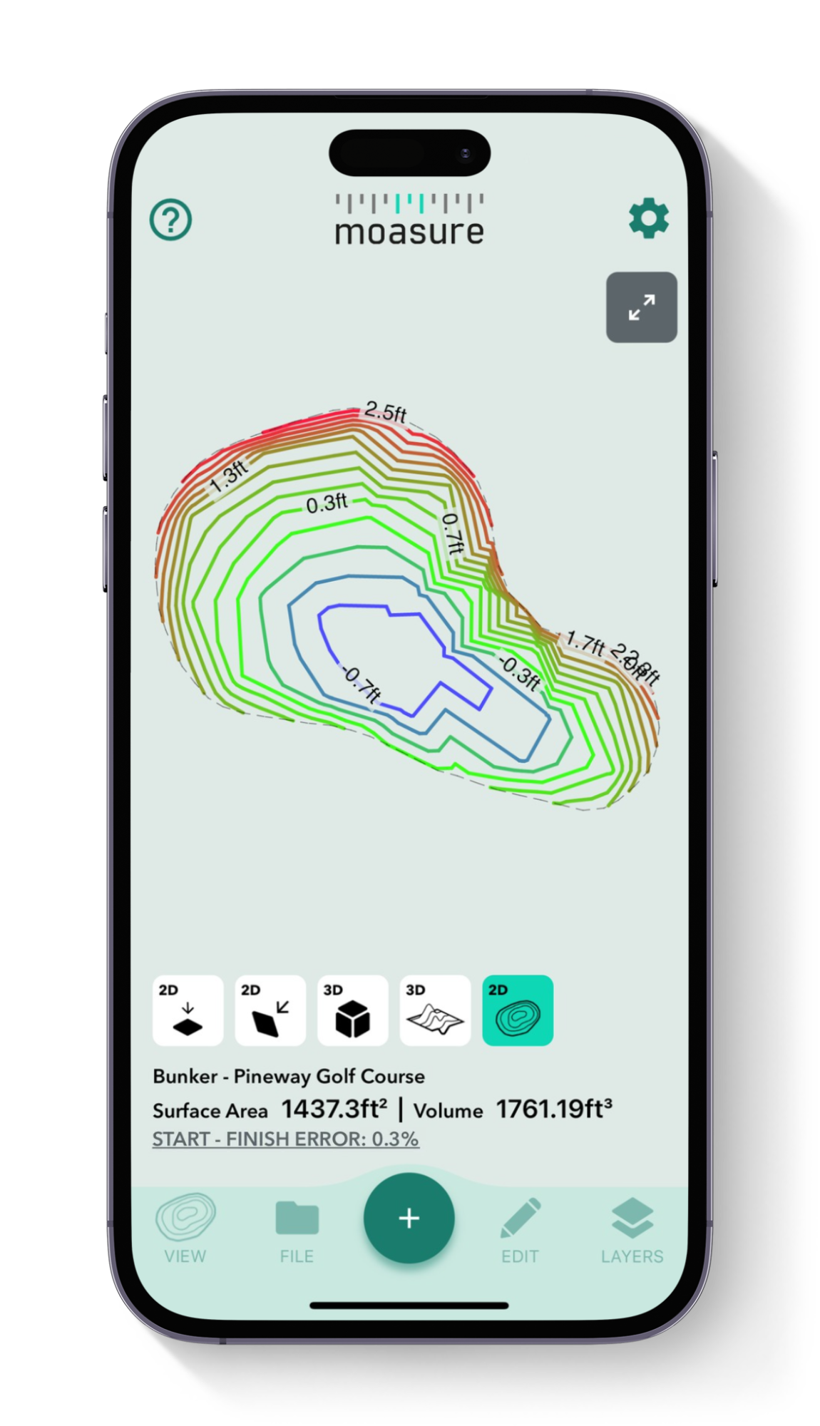
Topography/ Contour View
The contour view provides a 3D visualization of the site’s topography. By capturing elevation points across the terrain, Moasure creates contour lines that show gradients and elevations. This helps you understand site slopes and visualize the entire area, aiding in planning and material requirements.
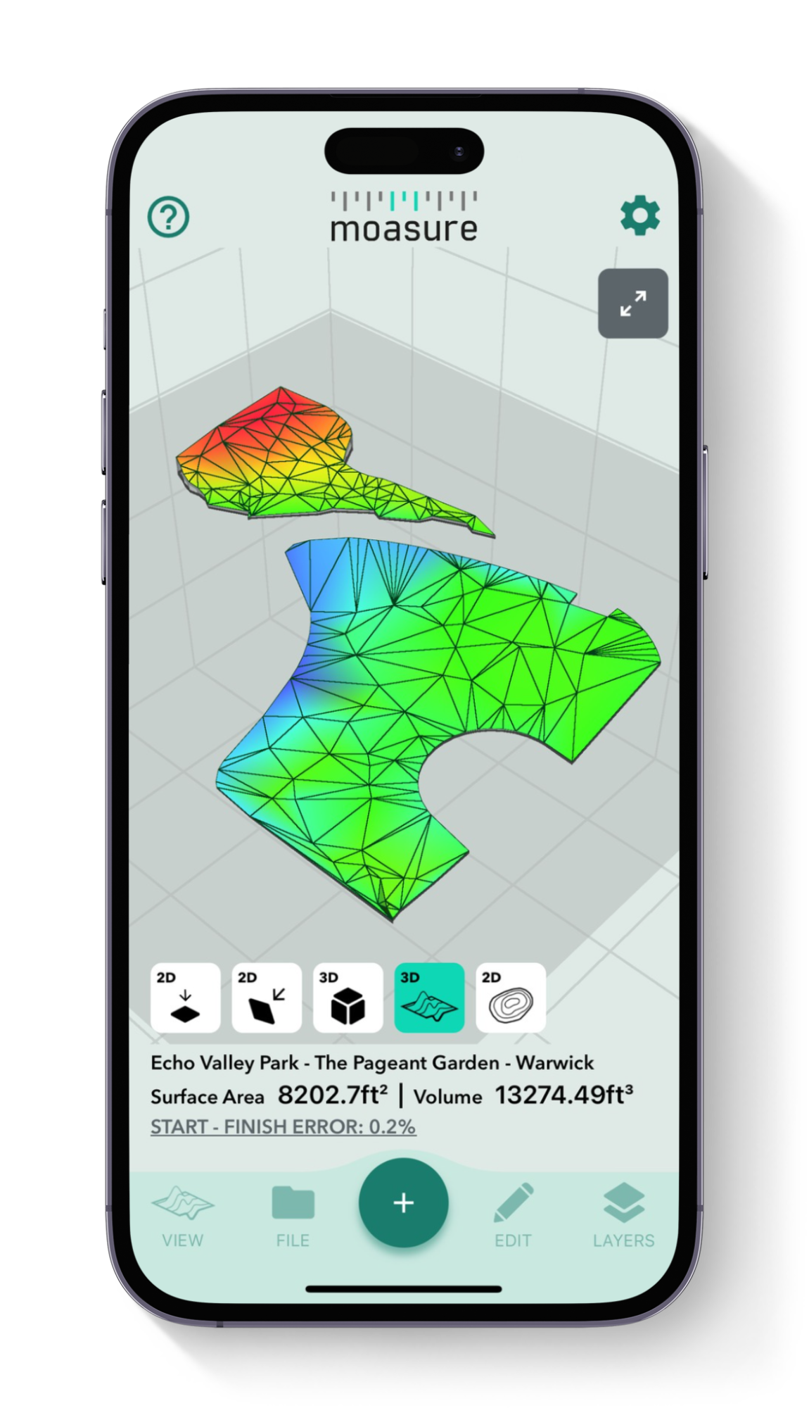
Surface Mesh View
This view generates a 3D surface map based on the measured area’s shape and elevation data, offering an accurate representation of irregular terrain. It’s particularly useful for applications where terrain and elevation variations impact planning, such as earthworks or landscaping projects.
Powerful in-app tools
Utilize the Moasure app's powerful suite of tools and features to enhance your measurements.
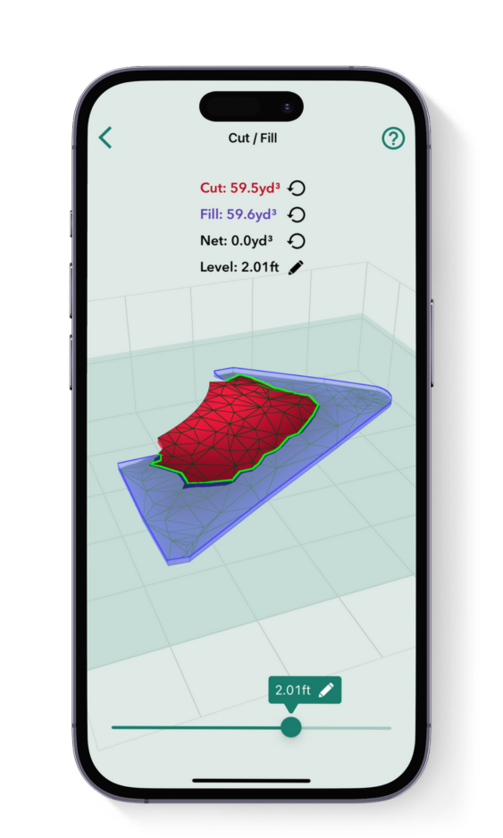
Cut & Fill tool
Calculate the volume of material needed to either excavate (cut) or add (fill) to bring a site to the desired level. Set your preferred level and instantly see the volume required for adjustments. The 'zero net volume' feature shows the exact level needed to avoid any material movement, making it useful for leveling sites in landscaping and construction.
Add Depth tool
Designed for estimating material volumes based on specific depths, this tool calculates how much material (like mulch, soil, or aggregate) is needed to cover a given area at a set depth. It’s effective for both flat and sloped sites, helping you avoid overestimating material costs and ensuring precise coverage.
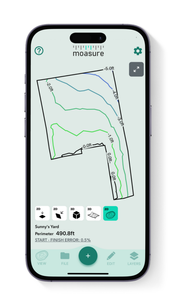
Topography / Contour view
The contour view provides a 3D visualization of the site’s topography. By capturing elevation points across the terrain, Moasure creates contour lines that show gradients and elevations. This helps you understand site slopes and visualize the entire area, aiding in planning and material requirements.
Surface Mesh view
This view generates a 3D surface map based on the measured area’s shape and elevation data, offering an accurate representation of irregular terrain. It’s particularly useful for applications where terrain and elevation variations impact planning, such as earthworks or landscaping projects.
View in 3D
Moasure captures the elevation of every point and generates a model of your measurement in 3D space. Impress your clients as Moasure instantly and automatically draws the area for you.
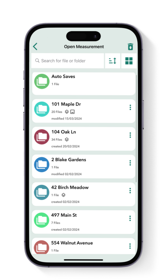
Organize your files
Save your Moasure files and organize them into folders, all within the app. Ideal for easy reference, simply access your measurements anytime you need them – Moasure’s organized file system streamlines your workflow and ensures quick access to your work.
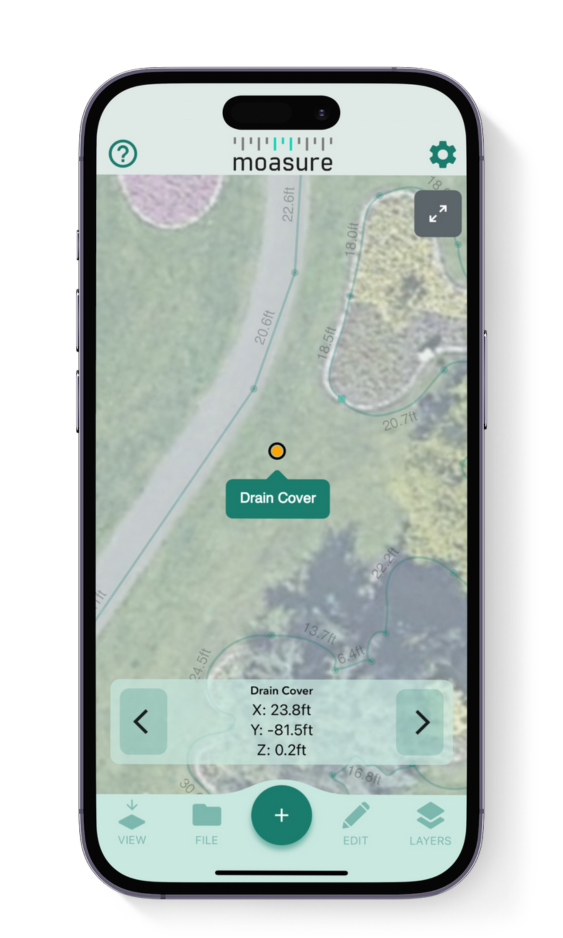
Add labels & backgrounds
Label points of interest and overlay your measurement on an aerial shot of the area to help clients or colleagues visualize your project.
Choose your Moasure
Try it with our 60-day money-back guarantee
Testimonials
Hear real stories from customers using Moasure
Over 100,000 professionals already love using Moasure to quickly map 3D terrain and calculate volume, saving them thousands of dollars in material ordering each year.
Being able to topo an entire project site is amazing
"We are a large excavation company that runs hundreds of thousands of dollars in GPS. With the speed and simplicity of Moasure, it cant be beat. Being able to topo an entire project site and immediately have volume, sqft, or lengths is absolutely amazing."
Honcoop Gravel Inc.
Excavation
Verified Review
The Cut/Fill feature is absolutely priceless!
"In the past, I would use my DeWalt rotary laser and graphing paper to plot out all of the elevation points, then sit down for about an hour and do the math. Now, with the Moasure, I can quickly and accurately calculate the cut and fill for a site."
Landpride Lot Service
Landscaping
Verified Review
Moasure reduces waste and saves money
"I am a landscaper who used to overestimate the amount of fill required. This tool has allowed me to be more precise with volume calculations, reducing waste and saving money."
David Wagner
Landscaping
Verified Review
Moasure saves time and money
"I love that I can get out of my truck and shoot elevations for determining how much dirt needs to be excavated. We used to have to set up our laser, hoping it was placed right to read elevations. Moasure saves time and money."
Millstone Custom Homes
Construction
Verified Review
Moasure is worth the investment
"I am a landscaper who used to overestimate the amount of fill required. Moasure's volume calculation feature has reduced material waste, saving us money."
Leanard Design
Landscaping
Verified Review
A game changer every contractor needs
"Love this tool!!! We've used our Moasure like crazy! It’s been amazing for our projects, especially for grading and leveling."
Paramount Remodeling
Remodeling & Renovation
Verified Review
Choose your Moasure
Try it with our 60-day money-back guarantee
Why Moasure outperforms traditional tools
Unlike other tools on the market, Moasure captures the precise x, y, and z coordinates of every point and automatically calculates the volume of any area.
Automatically calculate volume on areas
Add depth to measurements for material orders
Calculate true surface area
Automatically calculate cut & fill for site leveling
Automatically create a topography map
Ability to measure irregular shapes

Measuring
wheel
Laser
level
Tape
measure
Choose your Moasure
Try it with our 60-day money-back guarantee
Frequently asked questions
Everything you need to know about using Moasure to measure volume.
Moasure 2 PRO has a volume measurement error of ±1.5%, offering up to 98.5% accuracy with great user technique. This means that if you measure a 300ft³ area with an uneven surface for example, the volume calculation could be out by just 0.167yd³.
In comparison, Moasure 2 has a volume measurement error of ±3%, providing up to 97% accuracy. This means that if you measure a 300ft³ area with an uneven surface, the volume calculation could be out by 0.33yd³.
Choosing the right Moasure device for you will depend on the level of accuracy you require for your projects.
Yes, Moasure works on various materials by capturing elevation changes. You may find it easier to take Moasure out of the STICK in order to place it more easily on certain surfaces.
Yes, Moasure captures x, y & z data for each point you capture. All of this data can then be exported to DXF or DWG, ready to use across a wide range of CAD applications.
You can also use Moasure to generate detailed, scaled PDFs, edit data with CSV exports, or visualize measurements using PNG, JPG and SVG formats.

CHOOSE YOUR MOASURE RISK-FREE
100% money-back guarantee
Every Moasure device is tested to ensure it meets our accuracy and precision standards.
Plus, every order comes with a 60-day money-back guarantee as standard.
Thousands of professionals have transformed their workflow with Moasure.
Give it a try and you’ll never look back.

Choose your Moasure
Try it with our 60-day money-back guarantee
MOASURE FEATURES
See what else Moasure can do
With a range of professional features available, learn more about each one here.
Measure & draw simultaneously
Generate accurate dimensioned drawings while you move.
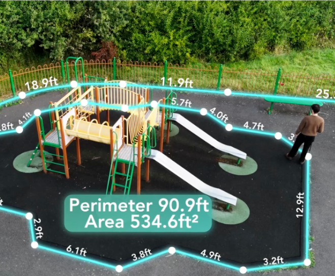
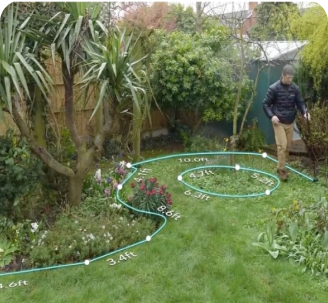
Calculate areas & perimeters
Automatically calculate the square footage and perimeter of a measured area.
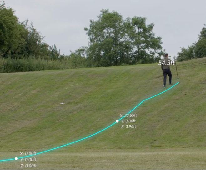
Calculate elevation as you move
Measure elevation, determine grade, calculate rise & run.

Add multiple layers
Capture multiple areas in one seamless measurement.
Measure 3D terrain & volume
Generate 3D terrain maps, calculate true surface area, volume, and contour lines.

Export measurements
Share measurements with clients, colleagues or your favorite design software.
Exclusive to Moasure 2 PRO
Layout mode
Stake out points based on entered coordinates.
Coming Soon
Floor plans
Instantly generate comprehensive floor plans.
New device coming soon.